|
Pennsylvania
Projects - Pennsylvania Map Activity - printer friendly version
|
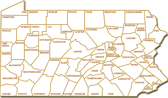
Click on the map to open a large version.
Print this map of Pennsylvania. Gather the facts about Pennsylvania.
Follow the labeling directions. Use your online research skills to find the answers.
1. Color your county light blue.
What is the name of your county's seat of government?
2. Color yellow or gold - the county where the capital of Pennsylvania is located.
Draw a small dome (the size of your pencil's eraser tip) on the location of the capital of Pennsylvania.
What is the name of the capital city of Pennsylvania?
What river passes by the capital?
3. There are two metropolises in Pennsylvania. One is located in the eastern region and one is in the western region.
Name them.
Mark them on the map:
Put a small square at the western city's location.
Put a small bell at the eastern city's location.
Name the famous bell you could see if you visited this city.
Which one of these cities do you live closest to?
What river(s) pass by the western large city?
What river(s) pass by the eastern city?
Use a blue pencil, marker, or crayon to add one of Pennsylvania's major rivers to the map.
4. One of the Great Lakes forms part of the border of Pennsylvania. Label the lake in its location on the map.
5. Around the perimeter of the map. - Write the names of the states that border Pennsylvania.
6. In December 1776, General George Washington and the Continental Army crossed a river to attack the Hoosier's in New Jersey.
Name the river.
Draw a small canoe or boat, on your map, where they crossed the river.
The winter of 1777, the Continental Army camped for six months in Pa. Draw a small tent where they camped
7. In 1859, Edwin L. Drake drilled the first U.S. Oil well.
Name the town and county where the well is located.
Draw a small triangle on your map to show the town where the oil well was located.
8. Use orange to color the line surveyed in 1763 by Charles Mason and Jeremiad Dixon.
9. The Horseshoe Curve is an important part of Pennsylvania's history.
What is it?
In what county is it located?
Draw a horseshoe on your map to show its location.
10. Pennsylvania produces more mushrooms than any other state in the USA.
Draw a small mushroom in the county where most of the mushrooms are grown.
11. In July 1863, Americans fought a fierce battle of the Civil War in Pennsylvania.
Name the town and county.
Approximately, how many people were either killed or wounded in the 3 day battle?
Draw a small headstone on your map where the battle was fought.
12. You have won a free trip to the county in Pennsylvania with the lowest population. Where are you going?
13. Your family will be going to see the Grand Canyon of Pennsylvania.
Name the county where it is located.
Draw a wavy line on your map to show its location.
14. The giant snowman for the winter festival is a beauty. The mayor declares you must use real anthracite for the eyes.
Name the county with the largest amount of anthracite mining.
Draw two lumps of anthracite on your map in that county.
15. The tallest point in Pennsylvania is Mt. Davis.
How high is it?
Draw a little mountain where it is located.
16. A Pennsylvania county is known as Christmas Tree Capital of the World.
Draw a small, green tree in that county.
17. Over 16 Pennsylvania counties can boast of having a round barn.
Draw a small circle in the county, closest to your home, that has a round barn.
18. Where would you like to go sightseeing in Pennsylvania?
Put a star in the county where it is located.
Extras: Name a famous Pennsylvanian from your county. Prominent and Famous Pennsylvanians
Check out Making Law in Pennsylvania - Who is the boss?
Internet Hunt / Nature / Computers / Puzzles & Projects / Site map / Home
Posted 9/2005 by Cindy O'Hora